🕒 Last updated on August 18, 2025
Erin intensifies after rare category five peak
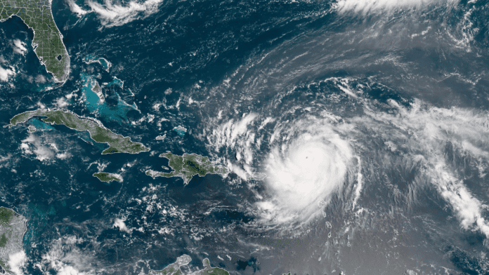
Hurricane Erin, the first hurricane of the 2025 Atlantic season, is growing in size even after being downgraded to a category three storm. The cyclone earlier reached a rare category five level on Saturday night, with winds peaking at 160 miles per hour (260 kilometers per hour). Though the wind speeds have since decreased, meteorologists say the system is continuing to expand in strength and coverage.
The storm had undergone rapid intensification as it moved across the Atlantic. Within just a short period, it grew explosively from a tropical storm to one of the strongest categories of hurricane. At its peak, it became one of the most powerful storms seen in the region in recent years. Experts tracking Erin say it has slowed slightly while turning northwards but remains a very dangerous system for the Caribbean.
Currently, Erin is passing north of Puerto Rico and the Dominican Republic. Winds are reaching up to 125 miles per hour (200 kilometers per hour). Warnings have been issued for surrounding islands as rain and wind continue to spread outward from the storm’s center. Rainfall totals are expected to reach up to six inches (15 centimeters) across the Virgin Islands and the Turks and Caicos Islands, which could trigger flash flooding in low-lying areas.
Storm warnings and coastal dangers
The US National Hurricane Center (NHC) has stated that Erin’s tropical-storm-strength winds now extend as far as 205 miles from the center of the storm. Hurricane-force winds are being measured up to 25 miles from the eye. This large coverage means that even islands not directly in the path of Erin’s center are experiencing dangerous weather conditions.
Tropical storm warnings remain in place for the Turks and Caicos Islands. Authorities have cautioned that heavy rains, powerful gusts, and rip currents will be serious risks. Rip currents, which can drag swimmers out to sea in seconds, are expected to become stronger around beaches and coastal areas.
Brazil rolls out $5.5 billion plan to ease impact of high U.S. tariffs on exports
The storm is also producing powerful ocean swells that will impact nearly the entire US East Coast. Coastal areas in Florida and the mid-Atlantic are expected to see the most hazardous surf conditions. High waves and choppy seas will continue to create challenges for ships, ports, and coastal communities. Bermuda and the Bahamas are also forecast to face life-threatening surf conditions along with heavy rainfall.
Because of the gale-force winds sweeping through parts of the Caribbean, the US Coast Guard has enforced restrictions on vessels in certain ports. These include harbors in St. Thomas and St. John in the US Virgin Islands, as well as six municipalities in Puerto Rico, including San Juan. The restrictions aim to prevent vessels from being caught in rough seas and strong winds.
Expanding size raises risk across the region
Although Erin has weakened from its record category five strength, its size has increased, making it dangerous over a much wider area. Meteorologists describe Erin as a storm that is spreading its impact across hundreds of miles. The growth in its radius means more islands and coastal zones are exposed to risks from high winds, heavy rain, and flooding.
The NHC has explained that Erin is not only powerful at its center but also far-reaching. This expansion is what makes the storm particularly concerning for nearby nations and territories. Even locations well away from the storm’s eye are expected to face damaging winds and hazardous surf conditions.
Rainfall in several regions, especially the Virgin Islands and Turks and Caicos, is expected to be intense. The risk of flash floods and landslides remains high in these areas. Swollen rivers, waterlogged soil, and storm surges from the sea could combine to worsen the hazards.
The storm has already disrupted air and sea travel in parts of the Caribbean. With tropical storm-force winds spreading outward, airlines, ports, and shipping companies have been forced to adjust schedules and put safety measures in place. Communities across the Caribbean are being urged to stay alert to warnings and advisories.
The National Oceanic and Atmospheric Administration (NOAA) has said that this year’s Atlantic hurricane season is expected to be “above normal,” with more storms reaching major hurricane strength. Global warming has been linked to the rising number of category four and five hurricanes in recent years, increasing risks for communities in hurricane-prone regions.

