🕒 Last updated on August 21, 2025
Hurricane Erin is moving northward through the Atlantic Ocean, and even though its strongest winds will not make landfall, the storm is already creating serious problems along the U.S. East Coast. The large size of the hurricane is pushing powerful waves toward shore, increasing the threat of rip currents, high surf, and coastal flooding.
Officials are warning beachgoers and residents in several states to stay cautious. The dangers are not limited to the Carolinas but stretch from Florida to southern New England. While the center of Erin remains hundreds of miles offshore, its impacts are spreading far and wide.
Rip currents and high surf are already a major threat
The biggest danger from Hurricane Erin right now is not its winds, but the sea. The storm is creating large swells that are reaching Atlantic beaches, making the water extremely dangerous.
These swells are fueling strong rip currents, which are powerful streams of water that pull away from the shore. They are difficult to spot and can drag even strong swimmers out to sea in seconds. Lifeguards in North Carolina already reported dozens of rescues earlier this week, with more expected as the waves grow larger.
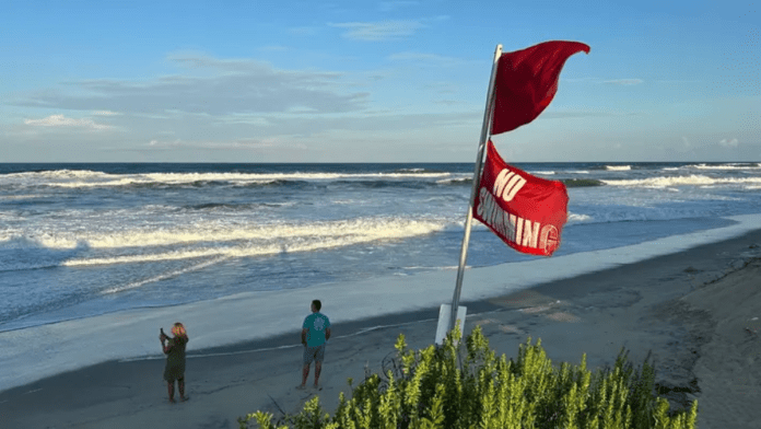
Experts say that people should not underestimate this hazard. Rip currents and rough seas are responsible for a significant number of storm-related deaths each year. Even if skies look clear and calm onshore, the ocean can be deadly. Red flags at the beach mean swimming is unsafe, and officials are urging everyone to stay out of the water until conditions improve.
⚡America’s biggest banks slash fossil fuel lending by $24 billion in 2025 despite political pressure
From Florida to New England, Atlantic beaches are experiencing pounding surf. These large, choppy waves will last through the week, making it risky for swimmers, surfers, and even boaters close to shore. Families planning to visit the beach are being told to pay attention to warning signs and lifeguard instructions.
Surge flooding in North Carolina and Virginia Tidewater
While high surf is the main problem for much of the East Coast, storm surge flooding is the major concern in North Carolina and parts of the Virginia Tidewater. Storm surge happens when hurricane winds push water from the ocean toward land. This can flood roads, beaches, and even neighborhoods during high tide.
Warnings are already in effect for the Outer Banks, where Highway 12 is especially vulnerable to overwash and washouts. Travel along this route may become dangerous or even impossible at times.
Inundation is expected during high tide, particularly on Thursday evening, when water levels could rise high enough to flood low-lying areas. Roads and properties near the coast may see standing water, especially in the Outer Banks and southern Chesapeake Bay.
Minor to moderate flooding is also being reported farther south in coastal South Carolina and southern North Carolina, including parts of Charleston. Farther north, from Delaware to New Jersey, forecasters say moderate coastal flooding is likely at high tide on Thursday and Friday. Water levels may stay above normal until the weekend before slowly receding.
Pro-Palestine protest blocks access to Edinburgh defense factory linked to F-35 jets
Even though Erin’s center is not close to shore, its broad size is pushing water inland across hundreds of miles. Coastal residents are being warned that this kind of flooding can happen quickly during high tide and should not be ignored.
Winds and rain add to the risks
Although Hurricane Erin’s strongest winds remain far offshore, its wide reach means parts of the East Coast are still feeling tropical-storm-force gusts. Eastern North Carolina is already under tropical storm warnings, and these winds are expected to continue into Thursday.
The winds may be strong enough to break tree limbs and cause scattered power outages. Areas farther up the coast, including the Delmarva Peninsula and even southeast New England, could also see gusty conditions through Friday. In Bermuda, tropical storm watches have also been issued as the storm passes nearby.
Hottest Month, Highest Costs: How Climate Extremes in July 2025 Shook the Global Economy
Rainfall is another impact tied to Erin. Outer rainbands are brushing eastern North Carolina, where 1 to 2 inches of rain may fall. This rain, combined with the storm surge flooding at high tide, increases the risk of standing water in low-lying areas.
Earlier in its journey, Erin already dropped heavy rain in Puerto Rico and the U.S. Virgin Islands, leading to flooding in some communities. In the coming days, the storm’s rain is expected to remain limited to narrow bands on the U.S. coast, but even smaller amounts of rainfall can worsen flooding where surge is already a problem.
Hurricane Erin has grown into a very large system, and its size means the effects are being felt across a wide stretch of the Atlantic seaboard. While the storm’s strongest hurricane-force winds are staying offshore, the threats from rip currents, high surf, storm surge flooding, and tropical-storm-force winds are serious and ongoing. Residents and visitors along the East Coast are being urged to take precautions and to follow local warnings to stay safe near the water.

